Skip to content
Monday 24 August 2026London --:--Frankfurt --:--Zurich --:--
NewslettersSearchEN · DE · FR
MorningWire

European business, markets and politics

FTSE 100
10,816.56
+0.64%
DAX
26,136.56
0.00%
CAC 40
8,484.43
0.00%
STOXX 50
6,462.22
0.00%
  • Europe
  • Markets
  • Business
  • Economy
  • Regulation
  • Politics
  • Opinion
More
GermanyFranceEU InstitutionsCompetitionPublic AffairsBankingTechnologyEnergy
  • Germany
  • France
  • Europe
  • Markets
  • Business
  • Economy
  • Regulation
  • Politics
  • Opinion
  • DE
Monday 21 September 2015 1:42 pm

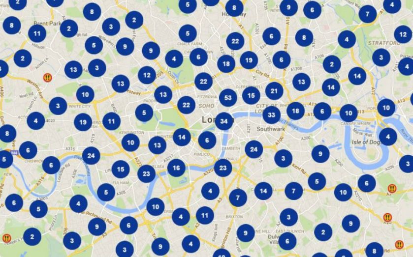
This TfL collision map shows London’s most dangerous junctions and roads when you’re on your bike, walking, driving or in a taxi

By: Lynsey Barber

Add as a preferred source on Google

If you're a cyclist in London, then Transport for London have published an amazingly useful map which can warn you of the spots on your journey where you're most at risk of being involved in an accident.

The new interactive map, found at collisionmap.london, lays out the exact location of every single collision in the capital over almost a decade, including the seriousness of the incident based on injuries and the type of vehicle involved.

And while cyclists may find it especially useful, the data collected from TfL and the police also provides the most comprehensive visualisation of the capital's roads to date, highlighting the danger spots for those on foot, driving, or travelling by taxi too.

The new effort is part of TfL's push to promote road safety as new figure published today in its annual road safety report show the number of people killed or seriously injured (KSI), has fallen by seven per cent on the previous year, the lowest levels since records began.

Read more: Transport for London secretly make a geographically accurate Tube map and it's strangely hypnotising

The data behind the map will soon be made available to developers, meaning there could soon be even better ways to identify dangerous spots in the city than the new map, such as using an app on your smartphone.

Combined with GPS, developers could even create an app which sends you alerts when you're approaching a dangerous junction to make you more vigilant of potential dangers.

“This mapping tool will enable us to work with our partners and local communities to make significant improvements in road safety. Alongside major modernisation work at junctions, effective enforcement by the police and action to make lorries safer, this is one of many measures we are taking to further reduce the number of people killed or seriously injured on our roads,” said TfL's surface transport managing director Leon Daniels.

The data will also be used with other sources by academics, researchers, and TfL itself, to identify trends and help tackle road safety issues in London.

Share this article

  • Facebook
  • X
  • LinkedIn
  • WhatsApp
  • Email

Similarly tagged content:

Sections

  • News

Categories

  • Business
  • Transport & Infrastructure

Trending Articles

  • Can debt-ridden Morrisons become a Big Four supermarket again?

  • Ratcliffe’s Ineos saves Runcorn plant

  • Amazon says it buys books in bulk to ‘improve products’

  • House prices in wealthy London boroughs fall by up to £300,000

  • Mike Ashley’s Frasers offers to pay personal shoppers in Harvey Nichols takeover

More from Morning Wire

  • TfL greenlights Wayve’s autonomous vehicles in the City

    Tech
    Wayve autonomous vehicle navigating a busy London street with iconic cityscape in the background
  • Lepas L8: China’s New SUV Means Business

    Life&Style
    Front view of a purple SUV, possibly a Lepas L8, with headlights on, on a dirt road against a cloudy sky.
  • Ordnance Survey revenue jumps as map maker goes digital

    Markets
    Ordnance Survey has revealed that an increase in demand for its data from financial services firms has helped its revenue near the £200m mark.
  • Hammersmith Bridge is a test for Burnham’s place-based growth

    Opinion
    Hammersmith Bridge closed in 2021 with fencing, banners, and traffic cones blocking access to the walkway.
  • Is the Audi Q9 the poshest Audi yet?

    Life&Style
    Dark blue Audi Q9 SUV parked on concrete with a modern building and sunset sky in the background.
  • From China with Love: Xpeng’s Luxury Ambition

    Motoring
    Tim Barnes-Clay observing the new dark green Xpeng G9L electric SUV in a modern showroom in China.
  • Moove Raises $250 Million at $2.1 Billion Valuation to Scale the Global Infrastructure Layer for Autonomous Mobility

    Business Wire
  • Vauxhall Mokka GSE review: on-track in the most surprising car of 2026

    Life&Style
    Blue and black Vauxhall Mokka driving on a winding country road with a driver visible, against a hilly landscape.
MorningWire

Independent European business, markets and political news for decision-makers.

Morning Briefing

Europe

  • Germany
  • France
  • EU Institutions
  • Europe

Business

  • Markets
  • Business
  • Economy
  • Regulation
  • Competition
  • Public Affairs

Editorial

  • Opinion
  • Editorial Policy
  • Corrections
  • Contact

Company

  • About Morning Wire
  • Privacy Policy
  • Terms of Use
  • Cookie Policy
© 2026 Morning Wire Ltd · Published by Morning Wire Media, Bahnhofstrasse 65, 8001 Zürich, Switzerland
Privacy · Terms · Cookies · Facebook